Spirit (rover)
 The Mars Exploration Rover-2 (MER-2) during testing for mobility and maneuverability | |
| Mission type | Rover |
|---|---|
| Operator | NASA |
| COSPAR ID | 2003-027A |
| SATCAT no. | 27827 |
| Website | Mars Exploration Rover |
| Mission duration | Planned: 90 Martian solar days (~92 Earth days) Operational: 2269 days from landing to last contact (2208 sols) Mobile: 1944 Earth days landing to final embedding (1892 sols) Total: 2695 days from landing to mission end (2623 sols) Launch to last contact: 6 years, 9 months, 12 days |
| Spacecraft properties | |
| Spacecraft type | Mars Exploration Rover |
| Launch mass | Total: 1,063 kg * rover: 185 kg * lander: 348 kg * backshell/parachute: 209 kg * heat shield: 78 kg * cruise stage: 193 kg * propellant: 50 kg[1] |
| Dry mass | 185 kilograms (408 lb) (Rover only) |
| Power | 140 watts |
| Start of mission | |
| Launch date | June 10, 2003, 17:58:47 UTC[2] June 10, 2003, 1:58:47 p.m. EDT[3][4] |
| Rocket | Delta II 7925-9.5[4][5] |
| Launch site | Cape Canaveral SLC-17A |
| End of mission | |
| Declared | May 25, 2011[3] |
| Last contact | March 22, 2010 |
| Orbital parameters | |
| Reference system | Heliocentric (transfer) |
| Mars rover | |
| Spacecraft component | Rover |
| Landing date | January 4, 2004, 04:35 UTC SCET MSD 46216 03:35 AMT |
| Landing site | 14°34′06″S 175°28′21″E / 14.5684°S 175.472636°E[6] |
| Distance driven | 7.73 km (4.8 mi) |
 The launch patch for Spirit, featuring Marvin the Martian NASA Mars rovers | |
Spirit, also known as MER-A (Mars Exploration Rover – A) or MER-2, is a Mars robotic rover, active from 2004 to 2010.[3] Spirit was operational on Mars for 2208 sols or 3.3 Martian years (2249 days; 6 years, 77 days). It was one of two rovers of NASA's Mars Exploration Rover Mission managed by the Jet Propulsion Laboratory (JPL). Spirit landed successfully within the impact crater Gusev on Mars at 04:35 Ground UTC on January 4, 2004, three weeks before its twin, Opportunity (MER-B), which landed on the other side of the planet. Its name was chosen through a NASA-sponsored student essay competition. The rover got stuck in a "sand trap" in late 2009 at an angle that hampered recharging of its batteries; its last communication with Earth was on March 22, 2010.
The rover completed its planned 90-sol mission (slightly less than 92.5 Earth days). Aided by cleaning events that resulted in more energy from its solar panels, Spirit went on to function effectively over twenty times longer than NASA planners expected. Spirit also logged 7.73 km (4.8 mi) of driving instead of the planned 600 m (0.4 mi),[7] allowing more extensive geological analysis of Martian rocks and planetary surface features. Initial scientific results from the first phase of the mission (the 90-sol prime mission) were published in a special issue of the journal Science.[8]
On May 1, 2009 (5 years, 3 months, 27 Earth days after landing; 21 times the planned mission duration), Spirit became stuck in soft sand.[9] This was not the first of the mission's "embedding events" and for the following eight months NASA carefully analyzed the situation, running Earth-based theoretical and practical simulations, and finally programming the rover to make extrication drives in an attempt to free itself. These efforts continued until January 26, 2010, when NASA officials announced that the rover was likely irrecoverably obstructed by its location in soft sand,[10] though it continued to perform scientific research from its current location.[11]
The rover continued in a stationary science platform role until communication with Spirit stopped on March 22, 2010 (sol 2208).[12][13] JPL continued to attempt to regain contact until May 24, 2011, when NASA announced that efforts to communicate with the unresponsive rover had ended, calling the mission complete.[14][15][16][17] A formal farewell took place at NASA headquarters shortly thereafter.
Mission overview


The primary surface mission for Spirit was planned to last at least 90 sols. The mission received several extensions and lasted about 2,208 sols. On August 11, 2007, Spirit obtained the second longest operational duration on the surface of Mars for a lander or rover at 1282 Sols, one sol longer than the Viking 2 lander. Viking 2 was powered by a nuclear cell whereas Spirit is powered by solar arrays. Until Opportunity overtook it on May 19, 2010, the Mars probe with longest operational period was Viking 1 that lasted for 2245 Sols on the surface of Mars. On March 22, 2010, Spirit sent its last communication, thus falling just over a month short of surpassing Viking 1's operational record. An archive of weekly updates on the rover's status can be found at the Spirit Update Archive.[18]
Spirit's total odometry is 7,730.50 meters (4.80 mi).[19]
Objectives

The scientific objectives of the Mars Exploration Rover mission were to:[20]
- Search for and characterize a variety of rocks and soils that hold clues to past water activity. In particular, samples sought will include those that have minerals deposited by water-related processes such as precipitation, evaporation, sedimentary cementation or hydrothermal activity.
- Determine the distribution and composition of minerals, rocks, and soils surrounding the landing sites.
- Determine what geologic processes have shaped the local terrain and influenced the chemistry. Such processes could include water or wind erosion, sedimentation, hydrothermal mechanisms, volcanism, and cratering.
- Perform calibration and validation of surface observations made by Mars Reconnaissance Orbiter instruments. This will help determine the accuracy and effectiveness of various instruments that survey Martian geology from orbit.
- Search for iron-containing minerals, identify and quantify relative amounts of specific mineral types that contain water or were formed in water, such as iron-bearing carbonates.
- Characterize the mineralogy and textures of rocks and soils and determine the processes that created them.
- Search for geological clues to the environmental conditions that existed when liquid water was present.
- Assess whether those environments were conducive to life.
NASA sought evidence of life on Mars, beginning with the question of whether the Martian environment was ever suitable for life. Life forms known to science require water, so the history of water on Mars is a critical piece of knowledge. Although the Mars Exploration Rovers did not have the ability to detect life directly, they offered very important information on the habitability of the environment during the planet's history.
Design and construction


Spirit (and its twin, Opportunity) are six-wheeled, solar-powered robots standing 1.5 meters (4.9 ft) high, 2.3 meters (7.5 ft) wide and 1.6 meters (5.2 ft) long and weighing 180 kilograms (400 lb). Six wheels on a rocker-bogie system enabled mobility over rough terrain. Each wheel had its own motor. The vehicle was steered at front and rear and was designed to operate safely at tilts of up to 30 degrees. The maximum speed was 5 centimeters per second (2.0 in/s);[22] 0.18 kilometers per hour (0.11 mph), although the average speed was about 1 centimeter per second (0.39 in/s). Both Spirit and Opportunity have pieces of the fallen World Trade Center's metal on them that were "turned into shields to protect cables on the drilling mechanisms".[23][24]
The solar arrays generated about 140 watts for up to four hours per Martian day (sol) while rechargeable lithium ion batteries stored energy for use at night. Spirit's onboard computer used a 20 MHz RAD6000 CPU with 128 MB of DRAM, 3 MB of EEPROM, and 256 MB of flash memory. The rover's operating temperature ranged from −40 to +40 °C (−40 to 104 °F). Radioisotope heater units provided a base level of heating, assisted by electrical heaters when necessary. A gold film and a layer of silica aerogel provided insulation.
Communications depended on an omnidirectional low-gain antenna communicating at a low data rate and a steerable high-gain antenna, both in direct contact with Earth. A low-gain antenna was also used to relay data to spacecraft orbiting Mars.
Science payload
The science instruments included:
- Panoramic Camera (Pancam) – examined the texture, color, mineralogy, and structure of the local terrain.
- Navigation Camera (Navcam) – monochrome with a higher field of view but lower resolution, for navigation and driving.
- Miniature Thermal Emission Spectrometer (Mini-TES) – identified promising rocks and soils for closer examination, and determined the processes that formed them.
- Hazcams, two B&W cameras with 120 degree field of view, that provided additional data about the rover's surroundings.
The rover arm held the following instruments:
- Mössbauer spectrometer (MB) MIMOS II – used for close-up investigations of the mineralogy of iron-bearing rocks and soils.
- Alpha particle X-ray spectrometer (APXS) – close-up analysis of the abundances of elements that make up rocks and soils.
- Magnets – for collecting magnetic dust particles.
- Microscopic Imager (MI) – obtained close-up, high-resolution images of rocks and soils.
- Rock Abrasion Tool (RAT) – exposed fresh material for examination by instruments on board.
Mission timeline

Spirit successfully landed on the surface of Mars on 04:35 Spacecraft Event Time (SCET) on January 4, 2004. This was the start of its 90-sol mission, but solar cell cleaning events would mean it was the start of a much longer mission, lasting until 2010. Spirit was targeted to a site that appears to have been affected by liquid water in the past, the crater Gusev, a possible former lake in a giant impact crater about 10 km (6.2 mi) from the center of the target ellipse[25] at 14°34′18″S 175°28′43″E / 14.5718°S 175.4785°E.[26] After the airbag-protected landing craft settled onto the surface, the rover rolled out to take panoramic images. These give scientists the information they need to select promising geological targets and drive to those locations to perform on-site scientific investigations.[27] The MER team named the landing site "Columbia Memorial Station," in honor of the seven astronauts killed in the Space Shuttle Columbia disaster.


On May 1, 2009 (sol 1892), the rover became stuck in soft sand, the machine resting upon a cache of iron(III) sulfate (jarosite) hidden under a veneer of normal-looking soil. Iron sulfate has very little cohesion, making it difficult for the rover's wheels to gain traction.[28][29]
On January 26, 2010 (sol 2155), after several months attempting to free the rover, NASA decided to redefine the mobile robot mission by calling it a stationary research platform. Efforts were directed in preparing a more suitable orientation of the platform in relation to the Sun in an attempt to allow a more efficient recharge of the platform's batteries. This was needed to keep some systems operational during the Martian winter.[30] On March 30, 2010, Spirit skipped a planned communication session and as anticipated from recent power-supply projections, had probably entered a low-power hibernation mode.[31]
The last communication with the rover was March 22, 2010 (sol 2208)[32] and there is a strong possibility the rover's batteries lost so much energy at some point that the mission clock stopped. In previous winters the rover was able to park on a Sun-facing slope and keep its internal temperature above −40 °C (−40 °F), but since the rover was stuck on flat ground it is estimated that its internal temperature dropped to −55 °C (−67 °F). If Spirit had survived these conditions and there had been a cleaning event, there was a possibility that with the southern summer solstice in March 2011, solar energy would increase to a level that would wake up the rover.[33]
Spirit remains silent at its location, called "Troy," on the west side of Home Plate. There was no communication with the rover after March 22, 2010 (sol 2208).[34]
It is likely that Spirit experienced a low-power fault and had turned off all sub-systems, including communication, and gone into a deep sleep, trying to recharge its batteries. It is also possible that the rover had experienced a mission clock fault. If that had happened, the rover would have lost track of time and tried to remain asleep until enough sunlight struck the solar arrays to wake it. This state is called "Solar Groovy." If the rover woke up from a mission clock fault, it would only listen. Starting on July 26, 2010 (sol 2331), a new procedure to address the possible mission clock fault was implemented.
JPL continued attempts to regain contact with Spirit until May 25, 2011, when NASA announced the end of contact efforts and the completion of the mission.[14][16][35] According to NASA, the rover likely experienced excessively cold "internal temperatures" due to "inadequate energy to run its survival heaters" that, in turn, was a result of "a stressful Martian winter without much sunlight." Many critical components and connections would have been "susceptible to damage from the cold."[16] Assets that had been needed to support Spirit were transitioned to support Spirit's then still-active Opportunity rover,[14] and Mars rover Curiosity which is exploring Gale Crater and has been doing so for more than six years.[36]
Discoveries
The rocks on the plains of Gusev are a type of basalt. They contain the minerals olivine, pyroxene, plagioclase and magnetite. They look like volcanic basalt, as they are fine-grained with irregular holes (geologists would say they have vesicles and vugs).[37][38]

Much of the soil on the plains came from the breakdown of the local rocks. Fairly high levels of nickel were found in some soils; probably from meteorites.[39]
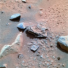
Analysis shows that the rocks have been slightly altered by tiny amounts of water. Outside coatings and cracks inside the rocks suggest water deposited minerals, maybe bromine compounds. All the rocks contain a fine coating of dust and one or more harder rinds of material. One type can be brushed off, while another needed to be ground off by the Rock Abrasion Tool (RAT).[40]
There are a variety of rocks in the Columbia Hills, some of which have been altered by water, but not by very much water.
The dust in Gusev Crater is the same as dust all around the planet. All the dust was found to be magnetic. Moreover, Spirit found the magnetism was caused by the mineral magnetite, especially magnetite that contained the element titanium. One magnet was able to completely divert all dust, hence all Martian dust is thought to be magnetic.[41] The spectra of the dust was similar to spectra of bright, low thermal inertia regions like Tharsis and Arabia that have been detected by orbiting satellites. A thin layer of dust, maybe less than one millimeter thick, covers all surfaces. Something in it contains a small amount of chemically bound water.[42][43]
Plains
 Above: An approximate true-color view of Adirondack, taken by Spirit's pancam. (January 19, 2004) Right:Digital camera image (from Spirit's Pancam) of Adirondack after a Rock Abrasion Tool grind (February 6, 2004) | |
| Feature type | Rock |
|---|---|
| Coordinates | 14°36′S 175°30′E / 14.6°S 175.5°E |
Observations of rocks on the plains show they contain the minerals pyroxene, olivine, plagioclase, and magnetite. These rocks can be classified in different ways. The amounts and types of minerals make the rocks primitive basalts—also called picritic basalts. The rocks are similar to ancient terrestrial rocks called basaltic komatiites.
Rocks of the plains also resemble the basaltic shergottites, meteorites that came from Mars. One classification system compares the amount of alkali elements to the amount of silica on a graph; in this system, Gusev plains rocks lie near the junction of basalt, picrobasalt, and tephrite. The Irvine-Barager classification calls them basalts.[37] Plains rocks have been very slightly altered, probably by thin films of water because they are softer and contain veins of light colored material that may be bromine compounds, as well as coatings or rinds. It is thought that small amounts of water may have gotten into cracks inducing mineralization processes).[37][38] Coatings on the rocks may have occurred when rocks were buried and interacted with thin films of water and dust. One sign that they were altered was that it was easier to grind these rocks compared to the same types of rocks found on Earth.
-
Cross-sectional drawing of a typical rock from the plains of Gusev crater. Most rocks contain a coating of dust and one or more harder coatings. Veins of water-deposited minerals are visible, along with crystals of olivine. Veins may contain bromine salts.

Columbia Hills
Scientists found a variety of rock types in the Columbia Hills, and they placed them into six different categories. The six are: Clovis, Wishbone, Peace, Watchtower, Backstay, and Independence. They are named after a prominent rock in each group. Their chemical compositions, as measured by APXS, are significantly different from each other.[44] Most importantly, all of the rocks in Columbia Hills show various degrees of alteration due to aqueous fluids.[45] They are enriched in the elements phosphorus, sulfur, chlorine, and bromine—all of which can be carried around in water solutions. The Columbia Hills' rocks contain basaltic glass, along with varying amounts of olivine and sulfates.[46][47] The olivine abundance varies inversely with the amount of sulfates. This is exactly what is expected because water destroys olivine but helps to produce sulfates.
Acid fog is believed to have changed some of the Watchtower rocks. This was in a 200 metres (660 ft) long section of Cumberland Ridge and the Husband Hill summit. Certain places became less crystalline and more amorphous. Acidic water vapor from volcanoes dissolved some minerals forming a gel. When water evaporated a cement formed and produced small bumps. This type of process has been observed in the lab when basalt rocks are exposed to sulfuric and hydrochloric acids.[48][49][50]
The Clovis group is especially interesting because the Mössbauer spectrometer (MB) detected goethite in it.[51] Goethite forms only in the presence of water, so its discovery is the first direct evidence of past water in the Columbia Hills's rocks. In addition, the MB spectra of rocks and outcrops displayed a strong decline in olivine presence,[46] although the rocks probably once contained much olivine.[52] Olivine is a marker for the lack of water because it easily decomposes in the presence of water. Sulfate was found, and it needs water to form. Wishstone contained a great deal of plagioclase, some olivine, and anhydrate (a sulfate). Peace rocks showed sulfur and strong evidence for bound water, so hydrated sulfates are suspected. Watchtower class rocks lack olivine consequently they may have been altered by water. The Independence class showed some signs of clay (perhaps montmorillonite a member of the smectite group). Clays require fairly long term exposure to water to form. One type of soil, called Paso Robles, from the Columbia Hills, may be an evaporate deposit because it contains large amounts of sulfur, phosphorus, calcium, and iron.[45] Also, MB found that much of the iron in Paso Robles soil was of the oxidized, Fe3+ form, which would happen if water had been present.[42]
Towards the middle of the six-year mission (a mission that was supposed to last only 90 days), large amounts of pure silica were found in the soil.[53] The silica could have come from the interaction of soil with acid vapors produced by volcanic activity in the presence of water or from water in a hot spring environment.[54]
After Spirit stopped working scientists studied old data from the Miniature Thermal Emission Spectrometer, or Mini-TES and confirmed the presence of large amounts of carbonate-rich rocks, which means that regions of the planet may have once harbored water. The carbonates were discovered in an outcrop of rocks called "Comanche."[55][56]
In summary, Spirit found evidence of slight weathering on the plains of Gusev, but no evidence that a lake was there. However, in the Columbia Hills there was clear evidence for a moderate amount of aqueous weathering. The evidence included sulfates and the minerals goethite and carbonates that only form in the presence of water. It is believed that Gusev crater may have held a lake long ago, but it has since been covered by igneous materials. All the dust contains a magnetic component that was identified as magnetite with some titanium. Furthermore, the thin coating of dust that covers everything on Mars is the same in all parts of Mars.
Astronomy


Spirit pointed its cameras towards the sky and observed a transit of the Sun by Mars' moon Deimos (see Transit of Deimos from Mars). It also took the first photo of Earth from the surface of another planet in early March 2004.
In late 2005, Spirit took advantage of a favorable energy situation to make multiple nighttime observations of both of Mars' moons Phobos and Deimos.[57] These observations included a "lunar" (or rather phobian) eclipse as Spirit watched Phobos disappear into Mars' shadow. Some of Spirit's star gazing was designed to look for a predicted meteor shower caused by Halley's Comet, and although at least four imaged streaks were suspect meteors, they could not be unambiguously differentiated from those caused by cosmic rays.[57]
A transit of Mercury from Mars took place on January 12, 2005, from about 14:45 UTC to 23:05 UTC. Theoretically, this could have been observed by both Spirit and Opportunity; however, camera resolution did not permit seeing Mercury's 6.1" angular diameter. They were able to observe transits of Deimos across the Sun, but at 2' angular diameter, Deimos is about 20 times larger than Mercury's 6.1" angular diameter. Ephemeris data generated by JPL Horizons indicates that Opportunity would have been able to observe the transit from the start until local sunset at about 19:23 UTC Earth time, while Spirit would have been able to observe it from local sunrise at about 19:38 UTC until the end of the transit.[clarification needed][58]
Equipment wear and failures
Both rovers passed their original mission time of 90 sols many times over. The extended time on the surface, and therefore additional stress on components, resulted in some issues developing.[34]
On March 13, 2006 (sol 778), the right front wheel ceased working[59] after having covered 4.2 mi (7 km) on Mars. Engineers began driving the rover backwards, dragging the dead wheel. Although this resulted in changes to driving techniques, the dragging effect became a useful tool, partially clearing away soil on the surface as the rover traveled, thus allowing areas to be imaged that would normally be inaccessible. However, in mid-December 2009, to the surprise of the engineers, the right front wheel showed slight movement in a wheel-test on sol 2113 and clearly rotated with normal resistance on three of four wheel-tests on sol 2117, but stalled on the fourth. On November 29, 2009 (sol 2098), the right rear wheel also stalled and remained inoperable for the remainder of the mission.
Scientific instruments also experienced degradation as a result of exposure to the harsh Martian environment and use over a far longer period than had been anticipated by the mission planners. Over time, the diamond in the resin grinding surface of the Rock Abrasion Tool wore down, after that the device could only be used to brush targets.[60] All of the other science instruments and engineering cameras continued to function until contact was lost; however, towards the end of Spirit's life, the MIMOS II Mössbauer spectrometer took much longer to produce results than it did earlier in the mission because of the decay of its cobalt-57 gamma ray source that has a half life of 271 days.
Honors

To rover
To commemorate Spirit's great contribution to the exploration of Mars, the asteroid 37452 Spirit has been named after it.[61] The name was proposed by Ingrid van Houten-Groeneveld who along with Cornelis Johannes van Houten and Tom Gehrels discovered the asteroid on September 24, 1960.
Reuben H. Fleet Science Center and the Liberty Science Center also have an IMAX show called Roving Mars that documents the journey of both Spirit and Opportunity, using both CG and actual imagery.
January 4, 2014, was celebrated as the tenth anniversary of its landing on many news sites, despite nearly four years since loss of communications.[62]
To honor the rover, the JPL team named an area near Endeavour Crater explored by the Opportunity rover, 'Spirit Point'.[63]
From rover
On January 27, 2004 (sol 22) NASA memorialized the crew of Apollo 1 by naming three hills to the north of "Columbia Memorial Station" as the Apollo 1 Hills. On February 2, 2004 (sol 28) the astronauts on Space Shuttle Columbia's final mission were further memorialized when NASA named a set of hills to the east of the landing site the Columbia Hills Complex, denoting seven peaks in that area as "Anderson", "Brown", "Chawla", "Clark", "Husband", "McCool", and "Ramon" in honour of the crew; NASA has submitted these geographical feature names to the IAU for approval.
Gallery
The rover could take pictures with its different cameras, but only the PanCam camera had the ability to photograph a scene with different color filters. The panorama views were usually built up from PanCam images. Spirit transferred 128,224 pictures in its lifetime.[64]
Views
-
Looking back from Bonneville crater to the landing site
-
False color image of "Mimi".

Panoramas


Microscopic images
-
Close-up of the rock Mazatzal, which was ground with the Rock Abrasion Tool on sol 82
-
Erosive effect of winds on hardened lava.


From orbit
-
Rover tracks up to sol 85 from Mars Global Surveyor
-
Spirit on September 29, 2006, beside Home Plate [65]

![Spirit on September 29, 2006, beside Home Plate [65]](http://upload.wikimedia.org/wikipedia/commons/thumb/5/56/Spirit_MRO.jpg/240px-Spirit_MRO.jpg)
Maps

from January 2004 landing thru to April 2008.
(see image above, at #Mars winter at Troy, for remaining movement)

 Clickable image: Clicking on the labels will open a new article.
See also
- Aeolis quadrangle
- Composition of Mars
- Curiosity rover
- ExoMars
- Exploration of Mars
- InSight
- Life on Mars
- List of surface features of Mars visited by Spirit and Opportunity
- Mars 2020 rover mission
- Opportunity rover
- Perseverance rover
- Scientific information from the Mars Exploration Rover mission
- Viking program
- List of software bugs related to space exploration
- Comparison of embedded computer systems on board the Mars rovers
- Zhurong (rover)
References
- ^ "Mars Exploration Rovers". NASA. Retrieved December 6, 2018.
- ^ "Spirit". NASA's Solar System Exploration website. Retrieved December 2, 2022.
- ^ a b c Nelson, Jon. "Mars Exploration Rover – Spirit". NASA. Archived from the original on January 28, 2018. Retrieved February 2, 2014.
- ^ a b "Launch Event Details – When did the Rovers Launch?". Retrieved April 25, 2009.
- ^ "Mars Exploration Rover project, NASA/JPL document NSS ISDC 2001 27/05/2001" (PDF). p. 5. Archived from the original (PDF) on May 27, 2010. Retrieved April 28, 2009.
- ^ Staff. "Mapping the Mars Rovers' Landing Sites". Esri. Retrieved May 4, 2014.
- ^ "NASA Spirit Rover Completes Mission on Mars" (Press release). Jet Propulsion Laboratory. May 25, 2011. Archived from the original on June 11, 2011. Retrieved May 26, 2011.
- ^ "Special Issue: Spirit at Gusev Crater". Science. 305 (5685): 737–900. August 6, 2004.
- ^ Henry Fountain (May 26, 2009). "Crater was Shaped by Wind and Water, Mars Rover Data Shows". The New York Times.
- ^ Amos, Jonathan (January 26, 2010). "Nasa accepts Spirit Mars rover 'stuck for good'". BBC News.
The US space agency (Nasa) has conceded defeat in its battle to free the Spirit rover from its Martian sand trap. The vehicle became stuck in soft soil back in May last year and all the efforts to extricate it have failed.
- ^ Brown, Dwayne; Webster, Guy (January 26, 2010). "Now a Stationary Research Platform, NASA's Mars Rover Spirit Starts a New Chapter in Red Planet Scientific Studies". NASA (Press release). Retrieved January 26, 2010.
Washington – After six years of unprecedented exploration of the Red Planet, NASA's Mars Exploration Rover Spirit no longer will be a fully mobile robot. NASA has designated the once-roving scientific explorer a stationary science platform after efforts during the past several months to free it from a sand trap have been unsuccessful.
- ^ September 30 – October 5, 2010 Spirit Remains Silent at Troy NASA. October 5, 2010.
- ^ A.J.S. Rayl Mars Exploration Rovers Update Archived March 18, 2012, at the Wayback Machine Planetary Society November 30, 2010
- ^ a b c Webster, Guy (May 25, 2011). "NASA's Spirit Rover Completes Mission on Mars". NASA. Retrieved October 12, 2011.
- ^ "NASA's Spirit Rover Completes Mission on Mars". NASA/JPL.
- ^ a b c "NASA Concludes Attempts to Contact Mars Rover Spirit". NASA. Archived from the original on October 11, 2011. Retrieved May 25, 2011.
- ^ Chang, Kenneth (May 24, 2011). "NASA to Abandon Mars Spirit Rover". The New York Times.
- ^ Cite error: The named reference
SpiritUpdateArchivewas invoked but never defined (see the help page). - ^ "Spirit Updates". Archived from the original on February 28, 2014. Retrieved May 14, 2012.
- ^ "Mars Exploration Rover Mission: Science". marsrovers.nasa.gov. Archived from the original on September 14, 2011. Retrieved July 25, 2008.
- ^ NASA.gov Archived July 21, 2011, at the Wayback Machine, MER-A 20040121a
- ^ "Mars Exploration Rover Mission: The Mission". marsrovers.jpl.nasa.gov.
- ^ Chang, Kenneth (November 7, 2004). "Martian Robots, Taking Orders From a Manhattan Walk-Up". The New York Times. Retrieved April 9, 2009.
- ^ Squyres, Steve (2005). Roving Mars: Spirit, Opportunity, and the Exploration of the Red Planet. Hyperion Press. pp. 113–117. ISBN 978-1-4013-0149-1.
- ^ "Gusev Crater: LandingSites". marsoweb.nas.nasa.gov.
- ^ Spaceflightnow.com, Destination Mars, Rover headed toward hilly vista for martian exploration
- ^ "APOD: 2004 January 14 – A Mars Panorama from the Spirit Rover". antwrp.gsfc.nasa.gov.
- ^ Maggie McKee (May 12, 2009). "Mars rover may not escape sand trap for weeks". New Scientist.
- ^ Chang, Kenneth (May 19, 2009). "Mars rover's 5 working wheels are stuck in hidden soft spot". The New York Times. ISSN 0362-4331. Retrieved May 19, 2009.
- ^ "Now A Stationary Research Platform, NASA's Mars Rover Spirit Starts a New Chapter in Red Planet Scientific Studies". NASA. January 26, 2010. Archived from the original on November 29, 2014. Retrieved June 26, 2009.
- ^ "Spirit May Have Begun Months-Long Hibernation". NASA. March 31, 2010.
- ^ "Spirit status". NASA. Retrieved February 28, 2011.
- ^ A.J.S. Rayl Spirit Sleeps Soundlessly, Opportunity Turns a Corner Archived April 1, 2012, at the Wayback Machine Planetary Society July 31, 2010
- ^ a b Reisert, Sarah (2017). "Life on Mars". Distillations. 3 (1): 42–45. Retrieved April 13, 2018.
- ^ Atkinson, Nancy (May 25, 2011). "End of the Road for Spirit Rover". Universe Today. Retrieved May 25, 2011.
- ^ mars.nasa.gov. "NASA's Opportunity Rover Mission on Mars Comes to End". NASA’s Mars Exploration Program. Retrieved May 23, 2020.
- ^ a b c McSween, HY; Arvidson, RE; Bell Jf, 3rd; Blaney, D; Cabrol, NA; Christensen, PR; Clark, BC; Crisp, JA; et al. (2004). "Basaltic Rocks Analyzed by the Spirit Rover in Gusev Crater". Science. 305 (5685): 842–845. Bibcode:2004Sci...305..842M. doi:10.1126/science.3050842. PMID 15297668.
{{cite journal}}: CS1 maint: numeric names: authors list (link) - ^ a b Arvidson, R. E.; Anderson, RC; Bartlett, P; Bell Jf, 3rd; Blaney, D; Christensen, PR; Chu, P; Crumpler, L; et al. (2004). "Localization and physical properties experiments conducted by Spirit at Gusev Crater". Science. 305 (5685): 821–824. Bibcode:2004Sci...305..821A. doi:10.1126/science.1099922. PMID 15297662. S2CID 31102951.
{{cite journal}}: CS1 maint: numeric names: authors list (link) - ^ Gellert, R.; Rieder, R.; Brückner, J.; Clark, B. C.; Dreibus, G.; Klingelhöfer, G.; Lugmair, G.; Ming, D. W.; et al. (2006). "Alpha Particle X-Ray Spectrometer (APXS): Results from Gusev crater and calibration report". Journal of Geophysical Research. 111 (E2): n/a. Bibcode:2006JGRE..111.2S05G. doi:10.1029/2005JE002555. hdl:2060/20080026124. S2CID 129432577.
- ^ Christensen, P.; Ruff, SW; Fergason, RL; Knudson, AT; Anwar, S; Arvidson, RE; Bandfield, JL; Blaney, DL; et al. (2004). "Initial Results from the Mini-TES Experiment in Gusev Crater from the Spirit Rover". Science. 305 (5685): 837–842. Bibcode:2004Sci...305..837C. doi:10.1126/science.1100564. PMID 15297667. S2CID 34983664.
- ^ Bertelsen, P.; Goetz, W; Madsen, MB; Kinch, KM; Hviid, SF; Knudsen, JM; Gunnlaugsson, HP; Merrison, J; et al. (2004). "Magnetic Properties on the Mars Exploration Rover Spirit at Gusev Crater". Science. 305 (5685): 827–829. Bibcode:2004Sci...305..827B. doi:10.1126/science.1100112. PMID 15297664. S2CID 41811443.
- ^ a b Bell, J (ed.) The Martian Surface. 2008. Cambridge University Press. ISBN 978-0-521-86698-9
- ^ Gelbert, R. (2004). "Chemistry of Rocks and Soils in Gusev Crater from the Alpha Particle X-ray Spectrometer". Science. 305 (5685): 829–832. Bibcode:2004Sci...305..829G. doi:10.1126/science.1099913. PMID 15297665. S2CID 30195269.
- ^ Squyres, Steven W.; Arvidson, Raymond E.; Blaney, Diana L.; Clark, Benton C.; Crumpler, Larry; Farrand, William H.; Gorevan, Stephen; Herkenhoff, Kenneth E.; et al. (2006). "Rocks of the Columbia Hills". Journal of Geophysical Research. 111 (E2): n/a. Bibcode:2006JGRE..111.2S11S. doi:10.1029/2005JE002562.
- ^ a b Ming, D. W.; Mittlefehldt, D. W.; Morris, R. V.; Golden, D. C.; Gellert, R.; Yen, A.; Clark, B. C.; Squyres, S. W.; et al. (2006). "Geochemical and mineralogical indicators for aqueous processes in the Columbia Hills of Gusev crater, Mars". Journal of Geophysical Research. 111 (E2): n/a. Bibcode:2006JGRE..111.2S12M. doi:10.1029/2005JE002560. hdl:1893/17114.
- ^ a b Schroder, C. (2005). "European Geosciences Union, General Assembly". Geophysical Research Abstracts. 7: 10254.
- ^ Christensen, P.R. (2005) Mineral Composition and Abundance of the Rocks and Soils at Gusev and Meridiani from the Mars Exploration Rover Mini-TES Instruments AGU Joint Assembly, May 23–27, 2005 http://www.agu.org/meetings/sm05/waissm05.html Archived May 13, 2013, at the Wayback Machine
- ^ "Signs of Acid Fog Found on Mars – SpaceRef". spaceref.com.
- ^ "Abstract: In-situ Evidence for Alteration by Acid Fog on Husband Hill, Gusev Crater, Mars. (2015 GSA Annual Meeting in Baltimore, Maryland, USA (1–4 November 2015))". gsa.confex.com.
- ^ COLE, Shoshanna B., et al. 2015. In-situ Evidence for Alteration by Acid Fog on Husband Hill, Gusev Crater, Mars. 2015 GSA Annual Meeting in Baltimore, Maryland, USA (November 1–4, 2015) Paper No. 94-10
- ^ Klingelhofer, G., et al. (2005) Lunar Planet. Sci. XXXVI abstr. 2349
- ^ Morris, R. V.; Klingelhöfer, G.; Schröder, C.; Rodionov, D. S.; Yen, A.; Ming, D. W.; De Souza, P. A.; Fleischer, I.; et al. (2006). "Mössbauer mineralogy of rock, soil, and dust at Gusev crater, Mars: Spirit's journey through weakly altered olivine basalt on the plains and pervasively altered basalt in the Columbia Hills". Journal of Geophysical Research. 111 (E2): n/a. Bibcode:2006JGRE..111.2S13M. doi:10.1029/2005JE002584. hdl:1893/17159.
- ^ "Mars Rover Uncovers Ancient Hot Springs". SkyandTelescope.com. May 22, 2008. Archived from the original on October 8, 2008. Retrieved August 1, 2012.
- ^ "NASA – Mars Rover Spirit Unearths Surprise Evidence of Wetter Past". www.nasa.gov.
- ^ "Outcrop of long-sought rare rock on Mars found".
- ^ Morris, R. V.; Ruff, S. W.; Gellert, R.; Ming, D. W.; Arvidson, R. E.; Clark, B. C.; Golden, D. C.; Siebach, K.; et al. (2010). "Identification of Carbonate-Rich Outcrops on Mars by the Spirit Rover". Science. 329 (5990): 421–4. Bibcode:2010Sci...329..421M. doi:10.1126/science.1189667. PMID 20522738. S2CID 7461676.
- ^ a b Jim Bell (Cornell University) et al. Pancam Projects: Spirit Night-time Imaging. Retrieved October 21, 2008
- ^ Chamberlin, Alan. "HORIZONS System". ssd.jpl.nasa.gov.
- ^ "JPL.NASA.GOV: Mars Exploration Rovers". www-b.jpl.nasa.gov. Archived from the original on July 21, 2011.
- ^ "NASAʼs Mars rovers and Steve Squyres keep going and going – Cornell Chronicle". www.news.cornell.edu.
- ^ "Mars Exploration Rover Mission: Spotlight". marsrovers.nasa.gov. Archived from the original on May 11, 2008. Retrieved June 30, 2006.
- ^ "Spaceflight Now – Mars Exploration Rovers – Revered Spirit rover landed on Mars a decade ago". www.spaceflightnow.com.
- ^ Greicius, Tony; Dunbar, Brian (August 10, 2011). "Arrival at 'Spirit Point' by Mars Rover Opportunity". NASA. Retrieved February 2, 2014.
- ^ mars.nasa.gov. "Mars Exploration Rover". marsrovers.jpl.nasa.gov.
- ^ "Catalog Page for PIA01879". photojournal.jpl.nasa.gov.
External links
JPL, MSSS, and NASA links
- JPL's Mars Exploration Rover Mission home page
- (obsolete JPL Mars Exploration Rover home page) Archived July 13, 2008, at the Wayback Machine
- Planetary Photojournal, NASA JPL's Planetary Photojournal for Spirit
- NASA TV Special Events Schedule for MER News Briefings at JPL
- Mission Status updates from NASA JPL Archived December 4, 2004, at the Wayback Machine
- Wikisource:NASA MER press briefings
- MER Analyst's Notebook, Interactive access to mission data and documentation
Other links
- SpaceFlightNow Spaceflightnow.com, Status Page last updated May 2004
- Cornell's rover site: Athena last update 2006
- Finding Spirit: interactive Mars atlas based on Viking images: you can zoom in/out and pan images, to find your preferred site. Spirit approximate position is 14.82°S (= −14.82°N), 184.85°W (= 5.15°E) (not working as of June 4, 2008)
- Google map with Spirit landing site marked
- New Scientist on Spirit Dust Devils Archived May 8, 2008, at the Wayback Machine, March 15, 2005
- New Scientist on Spirit wheel status, April 3, 2006
- Unmanned Spaceflight.com discussion on Spirit as of 2008-06-04 last updated 2008-06-04
- High-resolution video by Seán Doran that zooms in on Spirit's final location
- Archive of MER progress reports by A.J.S. Rayl at planetary.org
| General |
|  |
|---|---|---|
| Spirit rover | ||
| Opportunity rover | ||
| Instruments |
| |
| Related |
| |
| Past missions |  | |
|---|---|---|
| Current missions | ||
| Planned missions | ||
| Related | ||
Missions are ordered by launch date. Sign † indicates failure en route or before intended mission data returned. | ||
| Active |
|    | |||||||||
|---|---|---|---|---|---|---|---|---|---|---|---|
| Past |
| ||||||||||
| |||||||||||
| Future |
| ||||||||||
| |||||||||||
| Exploration |
| ||||||||||
Missions are ordered by launch date. Sign † indicates failure en route or before intended mission data returned. | |||||||||||
2011 in space | ||
|---|---|---|
2012 » | ||
| Space probe launches |
|    |
| Selected NEOs | ||
| Exoplanets |
| |
| Discoveries | ||
| Novae | ||
| Comets | ||
| Space exploration | ||
- 2003 robots
- 2004 on Mars
- Aeolis quadrangle
- Derelict landers (spacecraft)
- Mars Exploration Rover mission
- Mars robots
- Mars rovers
- Missions to Mars
- Robots of the United States
- Six-wheeled robots
- Soft landings on Mars
- Solar-powered robots
- Space probes launched in 2003
- Spacecraft decommissioned in 2011
- Spacecraft launched by Delta II rockets