Birmenstorf: Difference between revisions
Adding References section or removing map using AWB |
No edit summary |
||
| (42 intermediate revisions by 33 users not shown) | |||
| Line 1: | Line 1: | ||
{{distinguish|Birmensdorf}} |
|||
{{Use dmy dates|date=April 2022}} |
|||
{{Infobox Swiss town |
{{Infobox Swiss town |
||
| subject_name = Birmenstorf |
| subject_name = Birmenstorf |
||
| municipality_name = Birmenstorf |
|||
| municipality_type = municipality |
| municipality_type = municipality |
||
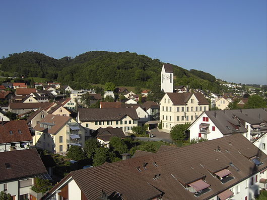
| image_photo = Birmenstorf01.jpg |
| image_photo = Birmenstorf01.jpg |
||
| |
| imagepath_coa = CHE Birmenstorf COA.svg |
||
| |
| imagepath_flag = CHE Birmenstorf Flag.svg |
||
| map = |
|||
| languages = German |
|||
| canton = Aargau |
| canton = Aargau |
||
| iso-code-region = CH-AG |
| iso-code-region = CH-AG |
||
| district = [[Baden (district, Aargau)|Baden]] |
| district = [[Baden (district, Aargau)|Baden]] |
||
|coordinates = {{coord|47|28|N|8|15|E|display=inline,title}} |
|||
| lat_d=47|lat_m=28|lat_NS=N|long_d=8|long_m=15|long_EW=E |
|||
| postal_code = 5413 |
| postal_code = 5413 |
||
| municipality_code = 4024 |
| municipality_code = 4024 |
||
| area = 7.80 |
| area = 7.80 |
||
| elevation = 382|elevation_description= |
| elevation = 382|elevation_description= |
||
| population = {{Swiss populations NC|CH-AG|4024}} | populationof = {{Swiss populations YM|CH-AG}} | popofyear = {{Swiss populations Y|CH-AG}} |
| population = {{Swiss populations NC|CH-AG|4024}} | populationof = {{Swiss populations YM|CH-AG}} | popofyear = {{Swiss populations Y|CH-AG}} |
||
| website = |
| website = birmenstorf.ch |
||
| mayor = |mayor_asof=|mayor_party= |
| mayor = |mayor_asof=|mayor_party= |
||
| mayor_title = |list_of_mayors = |
| mayor_title = |list_of_mayors = |
||
| places = |
| places = |
||
| demonym = |
| demonym = |
||
| neighboring_municipalities= [[Baden, Switzerland|Baden]], [[Birrhard]], [[Fislisbach]], [[Gebenstorf]], [[Mellingen]], [[Mülligen]], [[Windisch]], [[Wohlenschwil]] |
| neighboring_municipalities= [[Baden, Switzerland|Baden]], [[Birrhard]], [[Fislisbach]], [[Gebenstorf]], [[Mellingen]], [[Mülligen]], [[Windisch, Switzerland|Windisch]], [[Wohlenschwil]] |
||
| twintowns = |
| twintowns = |
||
|}} |
|}} |
||
'''Birmenstorf''' is a [[municipalities of Switzerland|municipality]] in the district of [[Baden (district, Aargau)|Baden]] in the [[Cantons of Switzerland|canton]] of [[Aargau]] in [[Switzerland]]. |
'''Birmenstorf''' is a [[municipalities of Switzerland|municipality]] in the district of [[Baden (district, Aargau)|Baden]] in the [[Cantons of Switzerland|canton]] of [[Aargau]] in [[Switzerland]]. |
||
[[File:ETH-BIB-Birmenstorf-LBS H1-024481.tif|thumb|Aerial view (1964)]] |
|||
==History== |
==History== |
||
The first written mention of Birmenstorf dates to 1146<ref name=HDS/> |
The first written mention of Birmenstorf dates to 1146.<ref name=HDS/> In 1415, the ''[[Old Swiss Confederacy|Eidgenossenschaft]]'' conquered the Aargau, and Birmenstorf as part of the [[Habsburg]] [[County of Baden]] came under their sovereignty. During the [[Reformation]], about a third of the population converted to [[Protestantism]]. The [[Choir (architecture)|choir]] of the old church with [[fresco]]s dating to 1440 still exists {{As of|2004|alt=today}}. |
||
For over 600 years, [[vineyard]]s have been cultivated in Birmenstorf. |
For over 600 years, [[vineyard]]s have been cultivated in Birmenstorf. |
||
== |
==Archeology== |
||
[[Archeology|Archeological]] findings indicate that the area was inhabited as early as the [[Stone Age]].{{Citation needed|date=April 2008}} The village proper was most likely founded by [[Alamanni]] settlers probably in the 6th century.{{Citation needed|date=April 2008}} |
[[Archeology|Archeological]] findings indicate that the area was inhabited as early as the [[Stone Age]].{{Citation needed|date=April 2008}} The village proper was most likely founded by [[Alamanni]] settlers probably in the 6th century.{{Citation needed|date=April 2008}} |
||
==Geography== |
==Geography== |
||
[[File:Birmenstorf Rebberg.JPG|thumb|left|Terraced vineyards outside Birmenstorf]] |
[[File:Birmenstorf Rebberg.JPG|thumb|left|Terraced vineyards outside Birmenstorf]] |
||
Birmenstorf has an area, {{as of|2006|lc=on}}, of {{ |
Birmenstorf has an area, {{as of|2006|lc=on}}, of {{convert|7.7|km2|sqmi|abbr=on}}. Of this area, 44% is used for agricultural purposes, while 36.8% is forested. Of the rest of the land, 15.8% is settled (buildings or roads) and the remainder (3.4%) is non-productive (rivers or lakes).<ref name=SFSO/> |
||
The municipality is located in the Baden district, in the valley of the [[Reuss |
The municipality is located in the Baden district, in the valley of the [[Reuss (river)|Reuss]] near its confluence with the [[Aare (river)|Aare]] and {{convert|4|km|mi|abbr=on}} west-south-west from [[Baden, Switzerland|Baden]]. It consists of the village of Birmenstorf and the [[hamlet (place)|hamlets]] of Lindmühle, Muntwil, Müslen and Oberhard as well as a new housing development. |
||
==Coat of |
==Coat of arms== |
||
The [[blazon]] of the municipal [[coat of arms]] is ''Vert a Garb Or.''<ref>[http://www.fotw.us/flags/ch-ag017.html Flags of the World.com] accessed |
The [[blazon]] of the municipal [[coat of arms]] is ''Vert a Garb Or.''<ref>[http://www.fotw.us/flags/ch-ag017.html Flags of the World.com] {{Webarchive|url=https://web.archive.org/web/20110604212341/http://www.fotw.us/flags/ch-ag017.html |date=4 June 2011 }} accessed 5 February 2010</ref> |
||
==Demographics== |
==Demographics== |
||
Birmenstorf has a population (as of {{Swiss populations date|CH-AG}}) of {{Swiss populations|CH-AG|4024}}.{{Swiss populations ref|CH-AG}} {{as of|2008}}, 19.0% of the population was made up of foreign nationals.<ref name=AG_pop>[http://www.ag.ch/staag/ Statistical Department of Canton Aargau -Bereich 01 -Bevölkerung] {{ |
Birmenstorf has a population (as of {{Swiss populations date|CH-AG}}) of {{Swiss populations|CH-AG|4024}}.{{Swiss populations ref|CH-AG}} {{as of|2008}}, 19.0% of the population was made up of foreign nationals.<ref name=AG_pop>[http://www.ag.ch/staag/ Statistical Department of Canton Aargau -Bereich 01 -Bevölkerung] {{Webarchive|url=https://web.archive.org/web/20120222045014/http://www.ag.ch/staag/ |date=22 February 2012 }} {{in lang|de}} accessed 20 January 2010</ref> Over the last 10 years the population has grown at a rate of 7.1%. Most of the population ({{as of|2000|lc=on}}) speaks German (90.3%), with Portuguese being second most common ( 2.0%) and Albanian being third ( 1.6%).<ref name=SFSO>[http://www.bfs.admin.ch/bfs/portal/en/index/regionen/02/key.html Swiss Federal Statistical Office] {{webarchive |url=https://web.archive.org/web/20160105172441/http://www.bfs.admin.ch/bfs/portal/en/index/regionen/02/key.html |date=5 January 2016 }} accessed 5 February 2010</ref> |
||
The age distribution, {{as of|2008|lc=on}}, in Birmenstorf is; 249 children or 10.0% of the population are between 0 and 9 years old and 301 teenagers or 12.1% are between 10 and 19. Of the adult population, 343 people or 13.8% of the population are between 20 and 29 years old. 388 people or 15.6% are between 30 and 39, 445 people or 17.9% are between 40 and 49, and 310 people or 12.4% are between 50 and 59. The senior population distribution is 236 people or 9.5% of the population are between 60 and 69 years old, 152 people or 6.1% are between 70 and 79, there are 62 people or 2.5% who are between 80 and 89,and there are 4 people or 0.2% who are 90 and older.<ref name=structure>[http://www.ag.ch/staag/ Statistical Department of Canton Aargau -Bevölkerungsdaten für den Kanton Aargau und die Gemeinden (Archiv)] {{ |
The age distribution, {{as of|2008|lc=on}}, in Birmenstorf is; 249 children or 10.0% of the population are between 0 and 9 years old and 301 teenagers or 12.1% are between 10 and 19. Of the adult population, 343 people or 13.8% of the population are between 20 and 29 years old. 388 people or 15.6% are between 30 and 39, 445 people or 17.9% are between 40 and 49, and 310 people or 12.4% are between 50 and 59. The senior population distribution is 236 people or 9.5% of the population are between 60 and 69 years old, 152 people or 6.1% are between 70 and 79, there are 62 people or 2.5% who are between 80 and 89, and there are 4 people or 0.2% who are 90 and older.<ref name=structure>[http://www.ag.ch/staag/ Statistical Department of Canton Aargau -Bevölkerungsdaten für den Kanton Aargau und die Gemeinden (Archiv)] {{Webarchive|url=https://web.archive.org/web/20120222045014/http://www.ag.ch/staag/ |date=22 February 2012 }} {{in lang|de}} accessed 20 January 2010</ref> |
||
{{as of|2000}}, there were 71 homes with 1 or 2 persons in the household, 426 homes with 3 or 4 persons in the household, and 396 homes with 5 or more persons in the household. The average number of people per household was 2.51 individuals.<ref name=zahlen/> {{as of|2008|alt=In 2008}} there were 486 single family homes (or 45.1% of the total) out of a total of 1,078 homes and apartments.<ref name=AG_data>[http://www.ag.ch/staag/ Statistical Department of Canton Aargau] {{ |
{{as of|2000}}, there were 71 homes with 1 or 2 persons in the household, 426 homes with 3 or 4 persons in the household, and 396 homes with 5 or more persons in the household. The average number of people per household was 2.51 individuals.<ref name=zahlen/> {{as of|2008|alt=In 2008}} there were 486 single family homes (or 45.1% of the total) out of a total of 1,078 homes and apartments.<ref name=AG_data>[http://www.ag.ch/staag/ Statistical Department of Canton Aargau] {{Webarchive|url=https://web.archive.org/web/20120222045014/http://www.ag.ch/staag/ |date=22 February 2012 }} {{in lang|de}} accessed 20 January 2010</ref> |
||
In the |
In the [[2007 Swiss federal election|2007 federal election]] the most popular party was the [[Swiss People's Party|SVP]] which received 35.6% of the vote. The next three most popular parties were the [[Christian Democratic People's Party of Switzerland|CVP]] (23.1%), the [[Free Democratic Party of Switzerland|FDP]] (12.2%) and the [[Social Democratic Party of Switzerland|SP]] (11.5%).<ref name=SFSO/> |
||
The entire Swiss population is generally well educated. In Birmenstorf about 81% of the population (between age |
The entire Swiss population is generally well educated. In Birmenstorf about 81% of the population (between age 25–64) have completed either non-mandatory [[Education in Switzerland#Secondary|upper secondary education]] or additional higher education (either university or a ''[[Fachhochschule]]'').<ref name=SFSO/> Of the school age population ({{as of|2009|alt=in the 2008/2009 school year}}), there are 180 students attending [[Education in Switzerland#Primary|primary school]], there are 22 students attending secondary school in the municipality.<ref name=zahlen/> |
||
The historical population is given in the following table:<ref name=HDS>{{HDS|1636|Birmenstorf}}</ref> |
The historical population is given in the following table:<ref name=HDS>{{HDS|1636|Birmenstorf}}</ref> |
||
{{Historical populations |
|||
{| class="wikitable" |
|||
|align=left |
|||
|- |
|||
! year |
|||
! population |
|||
|- |
|||
| 1658 |
|||
| c. 250 |
|||
|- |
|||
| 1799 |
| 1799 |
||
| 630 |
| 630 |
||
|- |
|||
| 1850 |
| 1850 |
||
| 992 |
| 992 |
||
|- |
|||
| 1900 |
| 1900 |
||
| 919 |
| 919 |
||
|- |
|||
| 1950 |
| 1950 |
||
| |
| 1197 |
||
|- |
|||
| 2000 |
| 2000 |
||
| |
| 2313 |
||
| ⚫ | |||
|- |
|||
| ⚫ | |||
==Economy== |
==Economy== |
||
{{as of|2007|In 2007}}, Birmenstorf had an unemployment rate of 1.68%. {{as of|2005}}, there were 129 people employed in the [[Primary sector of the economy|primary economic sector]] and about 23 businesses involved in this sector. 330 people are employed in the [[Secondary sector of the economy|secondary sector]] and there are 26 businesses in this sector. 328 people are employed in the [[Tertiary sector of the economy|tertiary sector]], with 68 businesses in this sector.<ref name=SFSO/> |
{{as of|2007|In 2007}}, Birmenstorf had an unemployment rate of 1.68%. {{as of|2005}}, there were 129 people employed in the [[Primary sector of the economy|primary economic sector]] and about 23 businesses involved in this sector. 330 people are employed in the [[Secondary sector of the economy|secondary sector]] and there are 26 businesses in this sector. 328 people are employed in the [[Tertiary sector of the economy|tertiary sector]], with 68 businesses in this sector.<ref name=SFSO/> |
||
{{as of|2000}} there was a total of 1,267 workers who lived in the municipality. Of these, 1,015 or about 80.1% of the residents worked outside Birmenstorf while 395 people commuted into the municipality for work. There were a total of 647 jobs (of at least 6 hours per week) in the municipality.<ref>[http://www.ag.ch/staag/ Statistical Department of Canton Aargau-Bereich 11 Verkehr und Nachrichtenwesen] {{Webarchive|url=https://web.archive.org/web/20120222045014/http://www.ag.ch/staag/ |date=22 February 2012 }} {{in lang|de}} accessed 21 January 2010</ref> |
|||
==Religion== |
==Religion== |
||
[[File:Birmenstorf kath Kirche mit Nebel.jpg|thumb|View on the Catholic Church]] |
[[File:Birmenstorf kath Kirche mit Nebel.jpg|thumb|View on the Catholic Church]] |
||
From the {{as of|2000|alt=2000 census}}, 1,108 or 47.9% are [[Roman Catholic]], while 766 or 33.1% belonged to the [[Swiss Reformed Church]]. Of the rest of the population, there are 7 individuals (or about 0.30% of the population) who belong to the [[Christian Catholic Church of Switzerland|Christian Catholic]] faith.<ref name=zahlen>[http://www.ag.ch/staag/ Statistical Department of Canton Aargau |
From the {{as of|2000|alt=2000 census}}, 1,108 or 47.9% are [[Roman Catholic]], while 766 or 33.1% belonged to the [[Swiss Reformed Church]]. Of the rest of the population, there are 7 individuals (or about 0.30% of the population) who belong to the [[Christian Catholic Church of Switzerland|Christian Catholic]] faith.<ref name=zahlen>[http://www.ag.ch/staag/ Statistical Department of Canton Aargau – Aargauer Zahlen 2009] {{Webarchive|url=https://web.archive.org/web/20120222045014/http://www.ag.ch/staag/ |date=22 February 2012 }} {{in lang|de}} accessed 20 January 2010</ref> |
||
==References== |
==References== |
||
| Line 92: | Line 83: | ||
==External links== |
==External links== |
||
{{commons category|Birmenstorf}} |
|||
*[http://www.birmenstorf.ch Official homepage of the municipality of Birmenstorf] |
*[http://www.birmenstorf.ch Official homepage of the municipality of Birmenstorf] |
||
*[http://www.birmenstorfer.ch Homepage of the viticulture cooperative] |
*[http://www.birmenstorfer.ch Homepage of the viticulture cooperative] |
||
{{Municipalities of the district of Baden}} |
{{Municipalities of the district of Baden}} |
||
{{Authority control}} |
|||
[[als:Birmenstorf]] |
|||
[[de:Birmenstorf]] |
|||
[[es:Birmenstorf]] |
|||
[[eo:Birmenstorf]] |
|||
[[fr:Birmenstorf]] |
|||
[[it:Birmenstorf]] |
|||
[[nl:Birmenstorf]] |
|||
[[pt:Birmenstorf]] |
|||
[[rm:Birmenstorf]] |
|||
[[ru:Бирменсторф]] |
|||
[[simple:Birmenstorf, Aargau]] |
|||
[[sv:Birmenstorf]] |
|||
[[vo:Birmenstorf]] |
|||
Latest revision as of 00:23, 18 May 2024
Birmenstorf | |
|---|---|
 | |
 Flag  Coat of arms | |
Location of Birmenstorf  | |
 Birmenstorf  Birmenstorf | |
| Coordinates: 47°28′N 8°15′E / 47.467°N 8.250°E | |
| Country | Switzerland |
| Canton | Aargau |
| District | Baden |
| Area | |
| • Total | 7.80 km2 (3.01 sq mi) |
| Elevation | 382 m (1,253 ft) |
| Population (31 December 2018)[2] | |
| • Total | 2,992 |
| • Density | 380/km2 (990/sq mi) |
| Time zone | UTC+01:00 (Central European Time) |
| • Summer (DST) | UTC+02:00 (Central European Summer Time) |
| Postal code(s) | 5413 |
| SFOS number | 4024 |
| ISO 3166 code | CH-AG |
| Surrounded by | Baden, Birrhard, Fislisbach, Gebenstorf, Mellingen, Mülligen, Windisch, Wohlenschwil |
| Website | birmenstorf SFSO statistics |
Birmenstorf is a municipality in the district of Baden in the canton of Aargau in Switzerland.

History[edit]
The first written mention of Birmenstorf dates to 1146.[3] In 1415, the Eidgenossenschaft conquered the Aargau, and Birmenstorf as part of the Habsburg County of Baden came under their sovereignty. During the Reformation, about a third of the population converted to Protestantism. The choir of the old church with frescos dating to 1440 still exists today[update].
For over 600 years, vineyards have been cultivated in Birmenstorf.
Archeology[edit]
Archeological findings indicate that the area was inhabited as early as the Stone Age.[citation needed] The village proper was most likely founded by Alamanni settlers probably in the 6th century.[citation needed]
Geography[edit]

Birmenstorf has an area, as of 2006[update], of 7.7 km2 (3.0 sq mi). Of this area, 44% is used for agricultural purposes, while 36.8% is forested. Of the rest of the land, 15.8% is settled (buildings or roads) and the remainder (3.4%) is non-productive (rivers or lakes).[4]
The municipality is located in the Baden district, in the valley of the Reuss near its confluence with the Aare and 4 km (2.5 mi) west-south-west from Baden. It consists of the village of Birmenstorf and the hamlets of Lindmühle, Muntwil, Müslen and Oberhard as well as a new housing development.
Coat of arms[edit]
The blazon of the municipal coat of arms is Vert a Garb Or.[5]
Demographics[edit]
Birmenstorf has a population (as of 31 December 2020) of 2,962.[6] As of 2008[update], 19.0% of the population was made up of foreign nationals.[7] Over the last 10 years the population has grown at a rate of 7.1%. Most of the population (as of 2000[update]) speaks German (90.3%), with Portuguese being second most common ( 2.0%) and Albanian being third ( 1.6%).[4]
The age distribution, as of 2008[update], in Birmenstorf is; 249 children or 10.0% of the population are between 0 and 9 years old and 301 teenagers or 12.1% are between 10 and 19. Of the adult population, 343 people or 13.8% of the population are between 20 and 29 years old. 388 people or 15.6% are between 30 and 39, 445 people or 17.9% are between 40 and 49, and 310 people or 12.4% are between 50 and 59. The senior population distribution is 236 people or 9.5% of the population are between 60 and 69 years old, 152 people or 6.1% are between 70 and 79, there are 62 people or 2.5% who are between 80 and 89, and there are 4 people or 0.2% who are 90 and older.[8]
As of 2000[update], there were 71 homes with 1 or 2 persons in the household, 426 homes with 3 or 4 persons in the household, and 396 homes with 5 or more persons in the household. The average number of people per household was 2.51 individuals.[9] In 2008[update] there were 486 single family homes (or 45.1% of the total) out of a total of 1,078 homes and apartments.[10]
In the 2007 federal election the most popular party was the SVP which received 35.6% of the vote. The next three most popular parties were the CVP (23.1%), the FDP (12.2%) and the SP (11.5%).[4]
The entire Swiss population is generally well educated. In Birmenstorf about 81% of the population (between age 25–64) have completed either non-mandatory upper secondary education or additional higher education (either university or a Fachhochschule).[4] Of the school age population (in the 2008/2009 school year[update]), there are 180 students attending primary school, there are 22 students attending secondary school in the municipality.[9]
The historical population is given in the following table:[3]
| Year | Pop. | ±% |
|---|---|---|
| 1799 | 630 | — |
| 1850 | 992 | +57.5% |
| 1900 | 919 | −7.4% |
| 1950 | 1,197 | +30.3% |
| 2000 | 2,313 | +93.2% |
Economy[edit]
As of 2007[update], Birmenstorf had an unemployment rate of 1.68%. As of 2005[update], there were 129 people employed in the primary economic sector and about 23 businesses involved in this sector. 330 people are employed in the secondary sector and there are 26 businesses in this sector. 328 people are employed in the tertiary sector, with 68 businesses in this sector.[4]
As of 2000[update] there was a total of 1,267 workers who lived in the municipality. Of these, 1,015 or about 80.1% of the residents worked outside Birmenstorf while 395 people commuted into the municipality for work. There were a total of 647 jobs (of at least 6 hours per week) in the municipality.[11]
Religion[edit]

From the 2000 census[update], 1,108 or 47.9% are Roman Catholic, while 766 or 33.1% belonged to the Swiss Reformed Church. Of the rest of the population, there are 7 individuals (or about 0.30% of the population) who belong to the Christian Catholic faith.[9]
References[edit]
- ^ a b "Arealstatistik Standard - Gemeinden nach 4 Hauptbereichen". Federal Statistical Office. Retrieved 13 January 2019.
- ^ "Ständige Wohnbevölkerung nach Staatsangehörigkeitskategorie Geschlecht und Gemeinde; Provisorische Jahresergebnisse; 2018". Federal Statistical Office. 9 April 2019. Retrieved 11 April 2019.
- ^ a b Birmenstorf in German, French and Italian in the online Historical Dictionary of Switzerland.
- ^ a b c d e Swiss Federal Statistical Office Archived 5 January 2016 at the Wayback Machine accessed 5 February 2010
- ^ Flags of the World.com Archived 4 June 2011 at the Wayback Machine accessed 5 February 2010
- ^ "Ständige und nichtständige Wohnbevölkerung nach institutionellen Gliederungen, Geburtsort und Staatsangehörigkeit". bfs.admin.ch (in German). Swiss Federal Statistical Office - STAT-TAB. 31 December 2020. Retrieved 21 September 2021.
- ^ Statistical Department of Canton Aargau -Bereich 01 -Bevölkerung Archived 22 February 2012 at the Wayback Machine (in German) accessed 20 January 2010
- ^ Statistical Department of Canton Aargau -Bevölkerungsdaten für den Kanton Aargau und die Gemeinden (Archiv) Archived 22 February 2012 at the Wayback Machine (in German) accessed 20 January 2010
- ^ a b c Statistical Department of Canton Aargau – Aargauer Zahlen 2009 Archived 22 February 2012 at the Wayback Machine (in German) accessed 20 January 2010
- ^ Statistical Department of Canton Aargau Archived 22 February 2012 at the Wayback Machine (in German) accessed 20 January 2010
- ^ Statistical Department of Canton Aargau-Bereich 11 Verkehr und Nachrichtenwesen Archived 22 February 2012 at the Wayback Machine (in German) accessed 21 January 2010
External links[edit]
| International | |
|---|---|
| National | |
| Other | |