Meppel: Difference between revisions
Added sources, removed "citation needed" notice |
Rescuing 1 sources and tagging 0 as dead. #IABot (v1.4beta) |
||
| Line 47: | Line 47: | ||
| area_land_km2 = {{Dutch municipality land area|Meppel}} |
| area_land_km2 = {{Dutch municipality land area|Meppel}} |
||
| area_water_km2 = {{Dutch municipality water area|Meppel}} |
| area_water_km2 = {{Dutch municipality water area|Meppel}} |
||
| elevation_footnotes = <ref name="AHN">{{cite web |
| elevation_footnotes = <ref name="AHN">{{cite web |
||
|url |
|url=http://www.ahn.nl/postcodetool |
||
|title |
|title=Postcodetool for 7941BJ |
||
|trans_title |
|trans_title= |
||
|language |
|language=Dutch |
||
|author |
|author= |
||
|date |
|date= |
||
|work |
|work=Actueel Hoogtebestand Nederland |
||
|publisher |
|publisher=Het Waterschapshuis |
||
|accessdate |
|accessdate=9 October 2013 |
||
|deadurl=yes |
|||
|archiveurl=https://web.archive.org/web/20130921053543/http://www.ahn.nl/postcodetool |
|||
|archivedate=21 September 2013 |
|||
|df= |
|||
}}</ref> |
|||
| elevation_m = 2 |
| elevation_m = 2 |
||
| elevation_max_footnotes = <!-- for references: use <ref> tags --> |
| elevation_max_footnotes = <!-- for references: use <ref> tags --> |
||
Revision as of 14:01, 8 June 2017
Meppel | |
|---|---|
 Meppeler toren (Tower of Meppel) | |
 Flag Coat of arms | |
 Location in Drenthe | |
| Coordinates: 52°42′N 6°11′E / 52.700°N 6.183°E | |
| Country | Netherlands |
| Province | Drenthe |
| Government | |
| • Body | Municipal council |
| • Mayor | Richard Korteland (VVD) |
| Area | |
| • Total | 57.03 km2 (22.02 sq mi) |
| • Land | 55.53 km2 (21.44 sq mi) |
| • Water | 1.50 km2 (0.58 sq mi) |
| Elevation | 2 m (7 ft) |
| Population (January 2021)[4] | |
| • Total | 34,386 |
| • Density | 619/km2 (1,600/sq mi) |
| Demonym | Meppeler |
| Time zone | UTC+1 (CET) |
| • Summer (DST) | UTC+2 (CEST) |
| Postcode | 7940–7949, 7965–7969 |
| Area code | 0522 |
| Website | www |
Meppel (Dutch pronunciation: [ˈmɛpəl] ) is a municipality and a city in the northeast of the Netherlands, in the south-west of the province Drenthe.
It developed in the 16th century as a transport and distribution inland harbour for turf. [citation needed] There used to be a lot of waterways in the town, but now only one remains.
People born in Meppel are occasionally referred to as 'Meppeler Muggen'[5]; this translates as mosquitos/gnats from Meppel. This is due to a traditional folk tale. The people of Meppel thought the church tower was on fire. After closer inspection it was only a swarm of mosquitos.[6]
Population centres
Broekhuizen, De Kolk, De Schiphorst, Havixhorst, Kolderveen, Kolderveense Bovenboer, Lindenhorst, Meppel, Nijentap, Nijeveen, Nijeveense Bovenboer, and Rogat.
Meppel
Meppel received city rights in 1644. It is the oldest town in the province of Drenthe.
Transportation
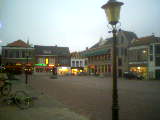
Photo gallery
-
Tower of Meppel
-
Square in town centre
-
City Hall
-
Two drawbridges
-
Watertower


References
- ^ "Richard Korteland" (in Dutch). Gemeente Meppel. Retrieved 9 October 2013.
{{cite web}}: Cite has empty unknown parameter:|trans_title=(help) - ^ "Kerncijfers wijken en buurten 2020" [Key figures for neighbourhoods 2020]. StatLine (in Dutch). CBS. 24 July 2020. Retrieved 19 September 2020.
- ^ "Postcodetool for 7941BJ". Actueel Hoogtebestand Nederland (in Dutch). Het Waterschapshuis. Archived from the original on 21 September 2013. Retrieved 9 October 2013.
{{cite web}}: Cite has empty unknown parameter:|trans_title=(help); Unknown parameter|deadurl=ignored (|url-status=suggested) (help) - ^ "Bevolkingsontwikkeling; regio per maand" [Population growth; regions per month]. CBS Statline (in Dutch). CBS. 1 January 2021. Retrieved 2 January 2022.
- ^ "CBOEK363 - EENIGE SCHELDNAMEN VAN DE EENE PLAATS OP DE ANDERE". Nederlandse Volksverhalenbank. Archived from the original on 28 April 2017. Retrieved 28 April 2017.
- ^ "De toren". Vrienden van de Grote of Mariakerk. Archived from the original on 30 December 2016. Retrieved 28 April 2017.
External links
Places adjacent to Meppel | ||||||||||||||||
|---|---|---|---|---|---|---|---|---|---|---|---|---|---|---|---|---|
| ||||||||||||||||
Municipalities of Drenthe | ||
|---|---|---|
 | ||
| ||
| International | |
|---|---|
| National | |
| Geographic | |
This Drenthe location article is a stub. You can help Wikipedia by expanding it. |