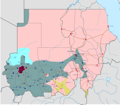
File:Deir ez-Zor clashes (2017).svg

Original file (SVG file, nominally 1,880 × 1,351 pixels, file size: 1.63 MB)
Captions
Captions
Summary
[edit]| Description |
Bahasa Indonesia: Dikuasai oleh Angkatan Bersenjata Suriah
Dikuasai oleh Negara Islam Irak dan Syam Bosanski: Pod kontrolom Vladinih snaga
Pod kontrolom ISIL-a Català: Controlat pel govern
Controlat per l'IS Čeština: Pod kontrolou syrské vlády
Pod kontrolou Syrské demokratické síly
Pod kontrolou Islámského státu Dansk: Kontrolleret af pro-Assad-styrker
Kontrolleret af syriske kurdere
Kontrolleret af Islamisk Stat (IS / ISIL) Deutsch: Von assadtreuen Kräften kontrolliert
Von den SDF kontrolliert
Vom Islamischen Staat (IS) kontrolliert English: Controlled by the Syrian Armed Forces
Controlled by the Syrian Democratic Forces (SDF)
Controlled by the Islamic State of Iraq and the Levant Español: Zonas controladas por el Gobierno Sirio
zonas controladas por el Kurdistán Sirio (Rojava)
Zonas controladas por el Estado Islámico de Irak y el Levante Français : Zones sous contrôle pro-Assad
Zones sous contrôle de FDS
Zones sous contrôle de l'EIIL (État islamique en Irak et au Levant) Hrvatski: Pod kontrolom Assadovih snaga
Pod kontrolom ISIL-a Italiano: Zone sotto il controllo di forze Pro-Assad
Zone sotto il controllo dello Stato Islamico dell'Iraq e del Levante Magyar: A szíriai hadsereg ellenőrzése alatt
Az Iszlám Állam ellenőrzése alatt Nederlands: In handen van de Syrische overheid
In handen van de Islamitische Staat (in Irak en de Levant) (ISIS) Português: Zonas controladas por forças pro-Assad
Zonas controladas pelo Estado Islâmico Română: Zone controlate de forțele pro-Assad
Zone controlate de forțele Statului Islamic Shqip: E kontrolluar nga forcat e Assadit
E knontrolluar nga Shteti Islamik i Irakut dhe Levantit Svenska: Kontrolleras av den syriska armén
Kontrolleras av den Syriska demokratiska styrkorna
Kontrolleras av den Islamiska staten (IS) Tiếng Việt: Kiểm soát bởi lực lượng thân Assad
Kiểm soát bởi lực lượng chống Assad Türkçe: Esad güçlerinin kontrolünde
IŞİD kontrolünde Български: Под контрол на правителствените сили
Под контрол на ИДИЛ Қазақша: үкіметтік күштердің Бақыланатын
ұйымын басқарады «Ирак пен Левант ислам мемлекеті» Русский: Контролируется правительственными силами
Контролируется организацией «Исламское государство»
Контролируется организацией «Сирийские демократические силы» Српски (ћирилица): Под контролом Асадових снага
Под контролом Исламске Државе Українська: Контролюється владою Сирії
Контролюється Ісламською Державою (ІДІЛ) Հայերեն : Կառավարվում է Սիրիական կառավարական ուժերի կողմից
Կառավարվում է "Իրաքի և Լևանտի իսլամական պետության" կողմից संस्कृतम् : असदसमर्थक सेनानाम् नियन्त्रणे क्षेत्राः
ISIS सेनानाम् नियन्त्रणे क्षेत्राः 한국어: 정부군 점령 지역
ISIS 점령 지역 中文: 巴沙尔·阿萨德政权控制的区域
伊斯兰国(ISIS)控制的区域 עברית : בשליטת כוחות נאמני אסד
בשליטת כוחות דאע"ש العربية : القوات الحكومية
قوات داعش فارسی : در دست ارتش سوریه
در دست داعش کوردی (عەرەبی): سوپای ڕژێم
دهوڵهتی ئیسلامی له عیڕاق و شام |
||||
| Date | |||||
| Source | Own work | ||||
| Author | MrPenguin20 | ||||
| Other versions |
|
||||
| SVG development |


Licensing
[edit]| This work contains information from OpenStreetMap, which is made available under the Open Database License (ODbL).
The ODbL does not require any particular license for maps produced from ODbL data. Prior to 1 August 2020, map tiles produced by the OpenStreetMap Foundation were licensed under the CC-BY-SA-2.0 license. Maps produced by other people may be subject to other licences. |
- You are free:
- to share – to copy, distribute and transmit the work
- to remix – to adapt the work
- Under the following conditions:
- attribution – You must give appropriate credit, provide a link to the license, and indicate if changes were made. You may do so in any reasonable manner, but not in any way that suggests the licensor endorses you or your use.
- share alike – If you remix, transform, or build upon the material, you must distribute your contributions under the same or compatible license as the original.
اشتباكات عنيفة بين القوات النظامية من جهة ومقاتلي جبهة النصرة وعدة كتائب اسلامية مقاتلة من جهة أخرى في حي الحويقة
http://www.syriahr.com/index.php?option=com_news&nid=15902&Itemid=2&task=displaynews#.ZUzn5mdjSt8
File history
Click on a date/time to view the file as it appeared at that time.
| Date/Time | Thumbnail | Dimensions | User | Comment | |
|---|---|---|---|---|---|
| current | 23:56, 20 November 2017 | 1,880 × 1,351 (1.63 MB) | TL565 (talk | contribs) | Reverted to version as of 03:16, 6 November 2017 (UTC) Hawijat Kati island captured https://www.almasdarnews.com/article/isis-mass-surrenders-large-deir-ezzor-island-250-terrorists-captured/ | |
| 02:36, 9 November 2017 | 1,880 × 1,351 (1.63 MB) | Kami888 (talk | contribs) | Multiple pro-SAA sources report continuing clashes at Qati Island or preparations to storm it. https://twitter.com/IvanSidorenko1/status/928432413356843010 | ||
| 03:16, 6 November 2017 | 1,880 × 1,351 (1.63 MB) | Kami888 (talk | contribs) | Matching with the syrian civil war module per request. | ||
| 13:52, 3 November 2017 | 1,880 × 1,351 (1.63 MB) | Kami888 (talk | contribs) | Battle is finished: http://www.telegraph.co.uk/news/2017/11/03/deir-ezzor-last-isil-stronghold-syria-liberated-army/ | ||
| 07:38, 3 November 2017 | 1,880 × 1,351 (1.64 MB) | Kami888 (talk | contribs) | Main part of DEZ under army, Battle of Hawiqa island ongoing | ||
| 22:29, 2 November 2017 | 1,880 × 1,351 (1.64 MB) | Kami888 (talk | contribs) | Hamidiyah, Sheikh Yassin, Rashdiya, parts of Ardhi, Jaradiq captured | ||
| 16:40, 1 November 2017 | 1,880 × 1,351 (1.64 MB) | Kami888 (talk | contribs) | jebaylah, jamiyat, park, and al-tarabia | ||
| 13:57, 31 October 2017 | 1,880 × 1,351 (1.64 MB) | Kami888 (talk | contribs) | Old airport, Khassarat, and Kenamat cleared. | ||
| 04:18, 29 October 2017 | 1,880 × 1,351 (1.64 MB) | Kami888 (talk | contribs) | SAA sources claim capture of entire Al-Ummal, al-Arbi, Municipal stadium, and Saqr island. https://twitter.com/sayed_ridha/status/924391198415921153 | ||
| 11:14, 26 October 2017 | 1,880 × 1,351 (1.64 MB) | Kami888 (talk | contribs) | industrial and cena districts captured. | ||
| 23:53, 21 October 2017 | 1,880 × 1,351 (1.65 MB) | Kami888 (talk | contribs) | Conflicting claims about the situation north of Junaynah, but no visual confirmation one way or the other - marked as unclear. | ||
| 12:57, 18 October 2017 | 1,880 × 1,351 (1.66 MB) | Kami888 (talk | contribs) | Kurds claim gains, unclear who controls Maishiyah. https://twitter.com/warcoresponted/status/920622717682049024 | ||
| 06:11, 18 October 2017 | 1,880 × 1,351 (1.64 MB) | Kami888 (talk | contribs) | https://twitter.com/warsmonitoring/status/920341952301797376 based on the new geolocations, it looks like the control north of the Euphrates is vastly different from what was previously assumed. Either the SDF never actually took those villages, or the... | ||
| 18:16, 16 October 2017 | 1,880 × 1,351 (1.66 MB) | Kami888 (talk | contribs) | update to match with the template map | ||
| 07:18, 27 September 2017 | 1,880 × 1,351 (1.65 MB) | Kami888 (talk | contribs) | updates | ||
| 11:20, 17 September 2017 | 1,880 × 1,351 (1.64 MB) | Kami888 (talk | contribs) | situation a bit confusing - matching current overall map | ||
| 04:48, 13 September 2017 | 1,880 × 1,351 (1.73 MB) | Kami888 (talk | contribs) | reported advances by SDF and SAA | ||
| 06:33, 12 September 2017 | 1,880 × 1,351 (1.72 MB) | Kami888 (talk | contribs) | clashes and unclear situation up north | ||
| 03:03, 11 September 2017 | 1,880 × 1,351 (1.7 MB) | Kami888 (talk | contribs) | Jabal Thardah | ||
| 09:14, 10 September 2017 | 1,880 × 1,351 (1.74 MB) | Kami888 (talk | contribs) | Siege on airport is broken | ||
| 12:41, 19 January 2017 | 1,880 × 1,351 (1.74 MB) | Kami888 (talk | contribs) | Most of the cemetery is contested, IS made further minor advances in and near the city according to loyalist sources. | ||
| 01:32, 17 January 2017 | 1,880 × 1,351 (1.74 MB) | Kami888 (talk | contribs) | pocket split in two according to loyalist sources | ||
| 14:50, 16 January 2017 | 1,880 × 1,351 (1.72 MB) | Kami888 (talk | contribs) | "Very intense clashes near the cemetery as IS continues attempt to isolate the Airbase from DeirEzzor city" - https://twitter.com/sayed_ridha/status/820955356557955072 | ||
| 06:54, 10 January 2017 | 1,880 × 1,351 (1.71 MB) | Kami888 (talk | contribs) | Better precision map. Sources on talk page. | ||
| 16:51, 29 August 2016 | 1,880 × 1,351 (2.2 MB) | Ermanarich (talk | contribs) | Update, derived from the informations at the Template. IS has been pushed out of al-Walid farms and the Panorama roundabout after Russian air raids. | ||
| 20:58, 17 August 2016 | 1,880 × 1,351 (2.21 MB) | Ermanarich (talk | contribs) | Clashes at Panorama roundabout and the al-Walid farms. Derived from latest changes of the Template. | ||
| 19:02, 14 May 2016 | 1,880 × 1,351 (2.2 MB) | Լրագրող (talk | contribs) | https://www.facebook.com/syriahro/photos/a.10150329947968115.393926.326766683114/10154272107838115/?type=3 | ||
| 14:07, 14 May 2016 | 1,880 × 1,351 (2.21 MB) | AlAboud83 (talk | contribs) | via SOHR https://www.facebook.com/syriahro/photos/a.10150329947968115.393926.326766683114/10154271203048115/?type=3&theater | ||
| 14:07, 14 May 2016 | 1,880 × 1,351 (2.21 MB) | AlAboud83 (talk | contribs) | via SOHR https://www.facebook.com/syriahro/photos/a.10150329947968115.393926.326766683114/10154271203048115/?type=3&theater | ||
| 02:55, 24 February 2016 | 1,880 × 1,351 (2.2 MB) | LightandDark2000 (talk | contribs) | No source for the changes. | ||
| 18:02, 23 February 2016 | 1,880 × 1,351 (2.21 MB) | HCPUNXKID (talk | contribs) | Reverted to version as of 23:43, 11 August 2015 (UTC) | ||
| 18:01, 23 February 2016 | 1,880 × 1,351 (2.21 MB) | HCPUNXKID (talk | contribs) | Reverted to version as of 01:14, 19 January 2016 (UTC) | ||
| 01:23, 19 January 2016 | 1,880 × 1,351 (2.2 MB) | AlAboud83 (talk | contribs) | fix | ||
| 01:14, 19 January 2016 | 1,880 × 1,351 (2.21 MB) | AlAboud83 (talk | contribs) | VIA Talkpage and maps | ||
| 23:43, 11 August 2015 | 1,880 × 1,351 (2.21 MB) | MrPenguin20 (talk | contribs) | Update - mostly around central Deir Ezzor. Slight changes around various streets. | ||
| 14:40, 16 January 2015 | 1,880 × 1,351 (2.21 MB) | MrPenguin20 (talk | contribs) | Changed islands with unclear control to blank. Moved frontline close to (but not including) Jafra, due to claims from al-Masdar of clashes in the area, and map from Peto Lucem showing similar fighting. Changes to Deir Ezzor city to show recent fighting. | ||
| 17:26, 10 January 2015 | 1,880 × 1,351 (1.6 MB) | XJ-0461 v2 (talk | contribs) | Reverted to version as of 00:41, 17 December 2014. More reliable sources such as EJM place Jafra in SAA hands. | ||
| 13:28, 10 January 2015 | 1,880 × 1,351 (1.6 MB) | MrPenguin20 (talk | contribs) | Jafra still in IS hands according to SOHR. | ||
| 00:41, 17 December 2014 | 1,880 × 1,351 (1.6 MB) | MrPenguin20 (talk | contribs) | Removed arrows (those battles are largely static atm, and arrows gives the impression of an ongoing push/momentum) | ||
| 22:13, 12 December 2014 | 1,880 × 1,351 (1.6 MB) | XJ-0461 v2 (talk | contribs) | Per https://twitter.com/EjmAlrai/status/543465540883603457. This post is 15 min more recent, saying that SAA has created a demarcation line in Jafra | ||
| 17:57, 12 December 2014 | 1,880 × 1,351 (1.6 MB) | AlAboud83 (talk | contribs) | Reverted to version as of 22:43, 4 December 2014,Via https://twitter.com/EjmAlrai/status/543461476108075008 | ||
| 22:27, 11 December 2014 | 1,880 × 1,351 (1.6 MB) | XJ-0461 v2 (talk | contribs) | Reverted to version as of 13:53, 9 November 2014 SAA has regain Jafra per http://www.alarabiya.net/ar/arab-and-world/syria/2014/12/11/%D9%82%D9%88%D8%A7%D8%AA-%D8%A7%D9%84%D8%A3%D8%B3%D8%AF-%D8%AA%D9%86%D8%A7%D9%81%D8%B3-%D8%AF%D8%A7%D8%B9%D8%B4-%D8%A8... | ||
| 22:43, 4 December 2014 | 1,880 × 1,351 (1.6 MB) | MrPenguin20 (talk | contribs) | ISIS advances in al-Jafra | ||
| 13:53, 9 November 2014 | 1,880 × 1,351 (1.6 MB) | MrPenguin20 (talk | contribs) | Slight change. Also according to deSyracuse - http://umap.openstreetmap.fr/fr/map/desyracuse-syria-civil-war-syria-civil-war-8-novem_21226#13/35.3163/40.1640 | ||
| 13:49, 9 November 2014 | 1,880 × 1,351 (1.6 MB) | MrPenguin20 (talk | contribs) | Updated according to map by deSyracuse - http://umap.openstreetmap.fr/fr/map/desyracuse-syria-civil-war-syria-civil-war-8-novem_21226#15/35.3332/40.1482 | ||
| 14:57, 21 October 2014 | 1,880 × 1,351 (1.6 MB) | MrPenguin20 (talk | contribs) | SOHR seems to be reporting strong element of back and forth between ISIS & SAA in Sina'ah. Added SAA offensive towards Hawiqah. | ||
| 14:49, 21 October 2014 | 1,880 × 1,351 (1.6 MB) | MrPenguin20 (talk | contribs) | Updated to show Saqer island fighting. | ||
| 19:51, 16 July 2014 | 1,880 × 1,351 (1.6 MB) | Kami888 (talk | contribs) | Changes per talk page | ||
| 12:49, 30 June 2014 | 1,880 × 1,351 (1.62 MB) | MrPenguin20 (talk | contribs) | Rashedya contested - https://www.facebook.com/syriahroe/posts/547476582027351 | ||
| 12:49, 18 June 2014 | 1,880 × 1,351 (1.62 MB) | MrPenguin20 (talk | contribs) | ISIS advance on North/Eastern side of the Euphrates. Hawija contested. | ||
| 22:31, 15 June 2014 | 1,880 × 1,351 (1.62 MB) | Spesh531 (talk | contribs) | making colors consistent with other maps of Template | ||
| 15:19, 3 June 2014 | 1,880 × 1,351 (1.77 MB) | HCPUNXKID (talk | contribs) | Hatla to black-grey per both [https://twitter.com/archicivilians/status/472791482726748160/photo/1 pro-opposition] & [https://www.facebook.com/photo.php?fbid=827637347255514&set=a.777540598931856.1073741827.777533765599206&type=1&theater pro-government... | ||
| 09:27, 12 April 2014 | 1,880 × 1,351 (1.68 MB) | HCPUNXKID (talk | contribs) | Per pro-opposition map: https://twitter.com/CdricLabrousse/status/454255552290242560/photo/1 | ||
| 15:22, 15 March 2014 | 1,880 × 1,351 (1.61 MB) | MrPenguin20 (talk | contribs) | Added clashes. | ||
| 23:50, 9 February 2014 | 1,880 × 1,351 (1.6 MB) | Sopher99 (talk | contribs) | Reverted to version as of 17:41, 17 January 2014 Syrian perspective is a pro-assad news outlet. If you want you can find an anti-assad map and compare what they agree on | ||
| 15:48, 4 February 2014 | 1,880 × 1,351 (1.6 MB) | MrPenguin20 (talk | contribs) | Updated in line with http://www.syrianperspective.com/wp-content/uploads/2013/12/1422452_10200930698570843_1204486355_n1.jpg. | ||
| 17:41, 17 January 2014 | 1,880 × 1,351 (1.6 MB) | MrPenguin20 (talk | contribs) | Update. | ||
| 15:43, 18 October 2013 | 1,880 × 1,351 (1.6 MB) | MrPenguin20 (talk | contribs) | Updated frontlines. | ||
| 14:08, 15 September 2013 | 1,880 × 1,351 (1.6 MB) | MrPenguin20 (talk | contribs) | Sina'a contested. Jebaylah neighbourhood labeled. al-Rashdiya neighbourhood contested. Al-Qussour neighbourhood labeled. | ||
| 11:56, 24 August 2013 | 1,880 × 1,351 (1.6 MB) | MrPenguin20 (talk | contribs) | All of Hawiqa island under opposition control. | ||
| 02:40, 24 August 2013 | 1,880 × 1,351 (1.6 MB) | MrPenguin20 (talk | contribs) | User created page with UploadWizard |
You cannot overwrite this file.
File usage on Commons
More than 100 pages use this file. The following list shows the first 100 pages that use this file only. A full list is available.
- User:Hermes79
- User:Hermes7979
- User:Magog the Ogre/Maps of conflicts/2016 August
- User:Magog the Ogre/Maps of conflicts/2017 January
- User:Magog the Ogre/Maps of conflicts/2017 November
- User:Magog the Ogre/Maps of conflicts/2017 October
- User:Magog the Ogre/Maps of conflicts/2017 September
- User:MrPenguin21
- File:2013 Hama Offensive.svg
- File:2015 Latakia Frontlines.svg
- File:Aleppo Offensives 2015.svg
- File:Aleppo offensive (October 2013).svg
- File:Attaques-terroristes-meurtrières-au-21eme-siecle.png
- File:Battle of Daraa City.svg
- File:Battle of Hasakah.svg
- File:Battle of Qamishli.svg
- File:Battle of Raqqa.svg
- File:Battle of Tadmur.svg
- File:Battle of Western Qalamoun.svg
- File:Battlefields in The Global War on Terror.svg
- File:Battlefields in The Global War on Terror - edit03.png
- File:Battlefields in The Global War on Terror - edit04.png
- File:Benghazi Conflict Detailed Map.png
- File:Benghazi Conflict Detailed Map.svg
- File:Boko Haram insurgency map.svg
- File:Countries by soldier count.svg
- File:Daraa 2018 gif.gif
- File:Deir ez-Zor clashes (17 september 2017).svg
- File:Deir ez-Zor clashes (2011).svg (file redirect)
- File:Deir ez-Zor clashes (2011-present).svg (file redirect)
- File:Deir ez-Zor clashes (2017).svg
- File:Derna Conflict Detailed Map.png
- File:East Congo conflict map.svg
- File:GSPC map.png
- File:ISIS (Grey) Territory Change 2014-2016.gif
- File:Iraqi Civil War map (2014–present).png
- File:Iraqi–Kurdish conflict map.png
- File:Islamist insurgency in Nigeria.svg
- File:Lebanese insurgency.svg
- File:Libyan Civil War.svg
- File:Libyan war final-fr.svg
- File:Map of Ongoing conflicts around the world.png
- File:Map of terror of the Islamic State (ad-Daula al-islāmiyya).png
- File:Mexico states map small war.PNG
- File:Mosul offensive (2015) map.png
- File:Number of Terrorist Incidents.png
- File:Ongoing Conflicts (1).png
- File:Pakistan-Waziristan-Map.png
- File:Political map Afar triangle.png
- File:Rif Damashq.svg
- File:Siege of Homs Map.svg
- File:Sinai insurgency.svg
- File:Sinai map.PNG
- File:Somali Civil War (2009-present).svg
- File:Syria and Iraq 2014-onward War map.png
- File:Syrian, Iraqi, and Lebanese insurgencies.png
- File:Syrian Civil War map.svg
- File:Syrian civil war.png
- File:Tadmur offensive (2015).jpg
- File:Turkish attack on Efrin.svg
- File:Yemeni Civil War.svg
- Template:City maps of ongoing civil wars
- Category:Aleppo
- Category:Attack
- Category:Battle of Aleppo
- Category:Battles in 2016
- Category:Battles in 2022
- Category:Battles in 2023
- Category:Battles of Syria
- Category:Battles of the Syrian Civil War
- Category:Cities in Syria
- Category:Civil wars
- Category:Conflicts
- Category:Conflicts by continent
- Category:Conflicts by country
- Category:Conflicts by type
- Category:Feuds
- Category:Fights
- Category:Liberation of Palmyra (2016)
- Category:Maps of Aleppo
- Category:Maps of Somali Civil War
- Category:Maps of conflicts
- Category:Maps of disputed territories
- Category:Maps of the Syrian Civil War in 2016
- Category:Maps of the Syrian Civil War in 2017
- Category:Maps of the Syrian Civil War in 2018
- Category:Maps of the Syrian Civil War in 2019
- Category:Maps of the Syrian Civil War in 2020
- Category:Maps of the Syrian Civil War in 2021
- Category:Maps of the Syrian Civil War in 2022
- Category:Military conflicts
- Category:Ongoing armed conflicts
- Category:Palmyra offensive (December 2016)
- Category:Quarrels
- Category:Rebellions
- Category:Riots
- Category:Schisms
- Category:Syrian Civil War
- Category:Terrorism
- Category:Uprisings
View more links to this file.
File usage on other wikis
The following other wikis use this file:
- Usage on ar.wikipedia.org
- Usage on azb.wikipedia.org
- Usage on be.wikipedia.org
- Usage on de.wikipedia.org
- Usage on en.wikipedia.org
- Usage on es.wikipedia.org
- Usage on fa.wikipedia.org
- Usage on fo.wikipedia.org
- Usage on fr.wikipedia.org
- Usage on fr.wikinews.org
- Usage on hu.wikipedia.org
- Usage on id.wikipedia.org
- Usage on ko.wikipedia.org
- Usage on ku.wikipedia.org
- Usage on nl.wikipedia.org
- Usage on pa.wikipedia.org
- Usage on pt.wikipedia.org
- Usage on pt.wikinews.org
- Usage on ru.wikipedia.org
- Usage on tr.wikipedia.org
- Usage on uk.wikipedia.org
- Usage on www.wikidata.org
- Usage on zh.wikipedia.org